expedition_retirement: (United States)
While Antelope Canyon might not have been well known prior to the 1990s, images of Monument Valley, also on the Navajo Nation, are globally known and iconic of the American West, thanks to John Ford and the movies he shot there, beginning with Stagecoach (starring John Wayne) in 1939. In all, Ford would shoot scenes for ten movies here. And, of course, the formations of Monument Valley form the backdrop from the famous scene in Forrest Gump when Forrest suddenly ends his cross-country running after 3 years, 2 months, 14 days, and 16 hours.

I had considered stopping here during a family trip west back in 2009, but Monument Valley is sufficiently out of the way to make the logistics of adding it too challenging, and while we effectively circled around it, we didn't actually visit. Which meant that I absolutely wanted to visit this iconic location on this trip. While we could have just driven around the loop road in the valley, I was concerned about how well our car would handle the conditions of this unpaved road. That was one reason to consider a guided tour. But a tour would also take us deeper into the valley, into areas closed to the general public, and would provide us with a guide who could talk to us about what we were seeing. I decided on a two-part, all-day tour. In the morning, we would explore Monument Valley, and after a break for lunch, we would explore the adjacent Mystery Valley, once the home to the people known the the Navajo as "Anasazi" and now commonly called "Ancestral Puebloans".

Because the tour was inside the Navajo Nation, the meeting time was at 8 MDT, we had to give ourselves an extra hour in calculating our wake up time, as we were staying in Page the night before, on MST. With a drive of almost two hours from Page, we had to leave by about 5am MST to be sure we weren't late for our tour. Luckily, we properly set our alarm and had no issues during our drive across the Navajo Nation in the early morning light. We arrived at the starting point of the tour with plenty of time to spare.
West Mitten ButteWest Mitten ButteJohn Ford Point
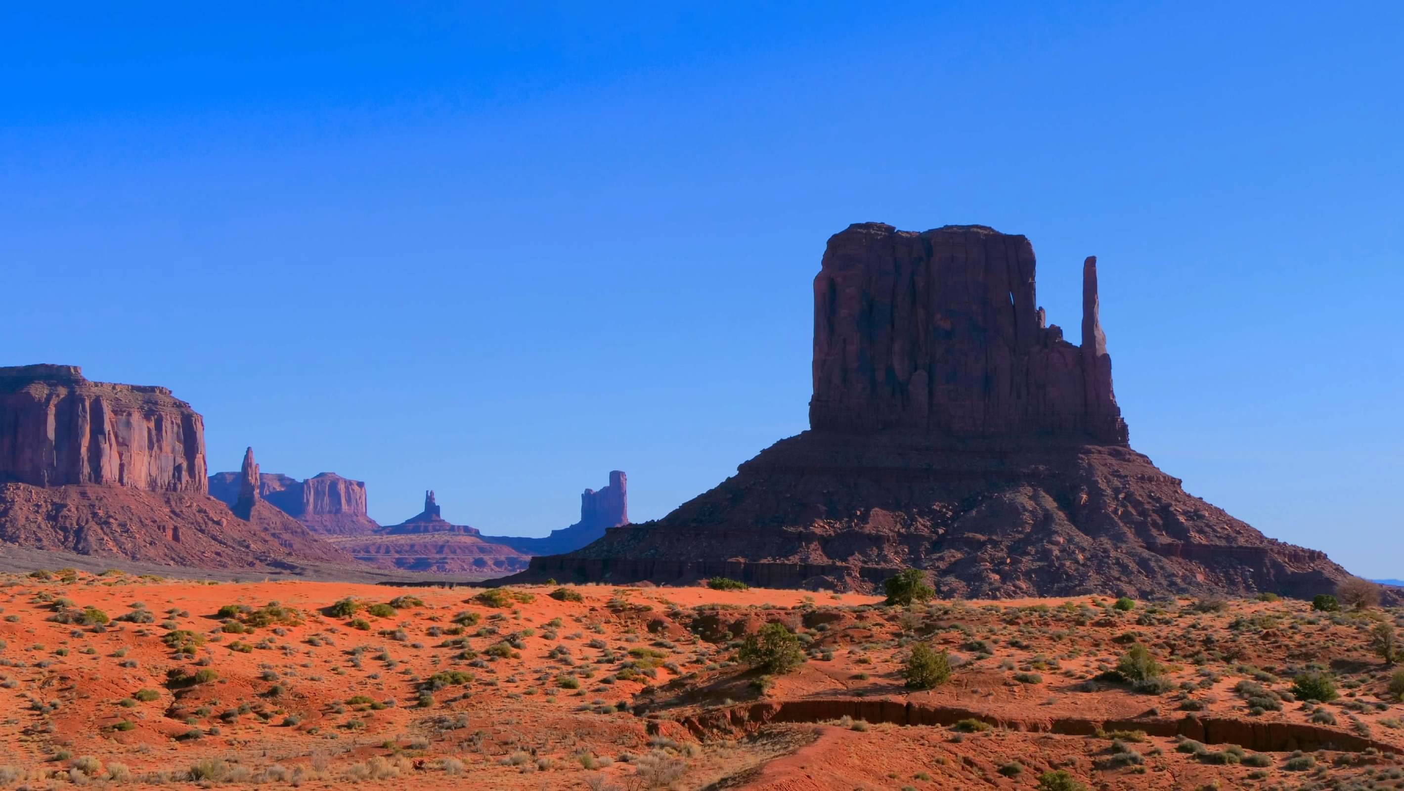
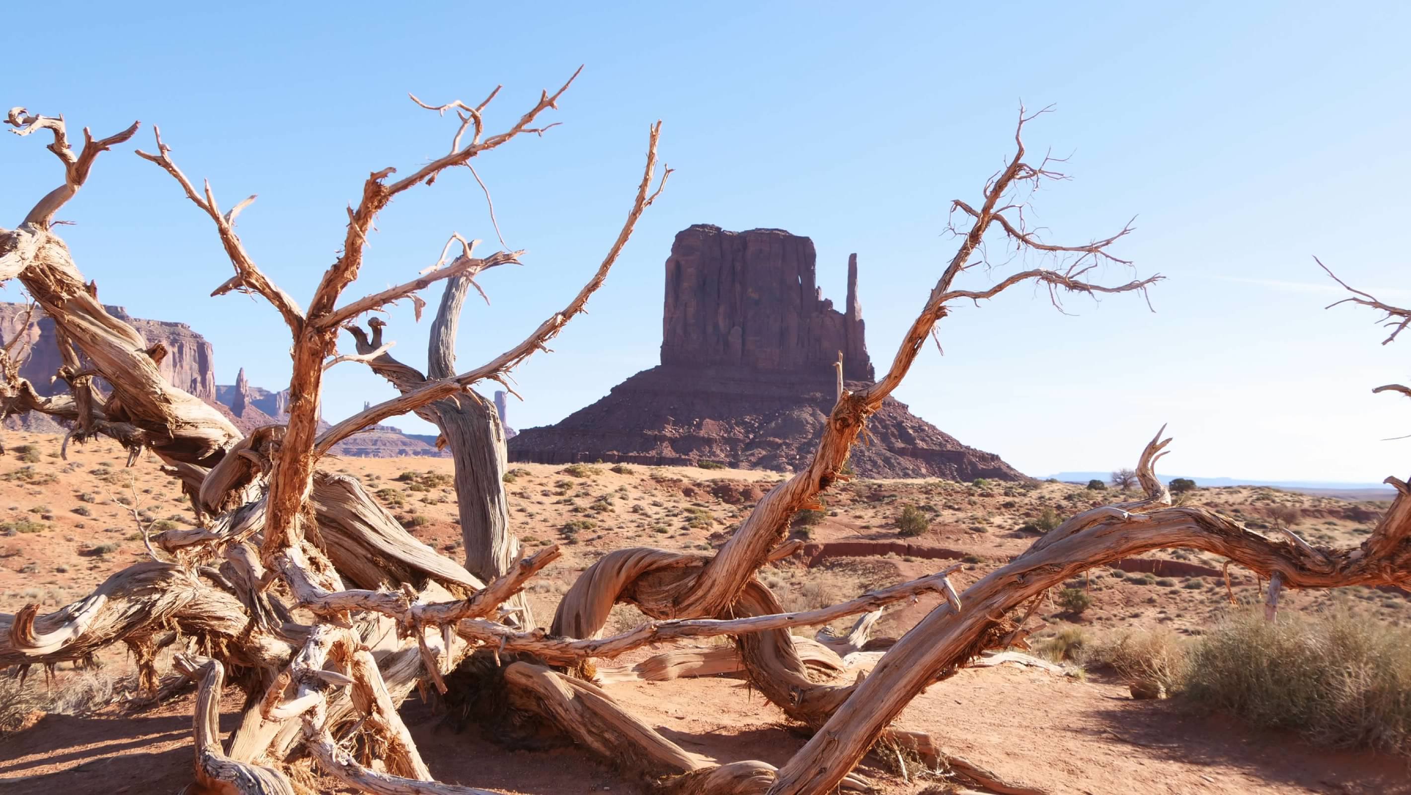
The tour started out with stops to see the formations made famous by the various movies filmed here. Along the way, our tour guide shared stories about the history of the Valley, as well as Navajo stories he learned from his grandfather (and which he is now passing on to his grandchildren). We also visited John Ford point, with its panoramic vista. We then left the publicly accessible road and headed deeper into the valley. We stopped at a traditional Navajo hogan, where we met a woman to hand weaves traditional Navajo rugs and listened to her talk about her life here in the Valley. It was an important reminder that this valley isn't just a tourist attraction...it is the ancestral home for these people.
Big Hogan ArchMoccasin ArchEye of the Sun ArchEar of the Wind Arch
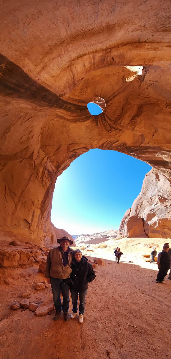
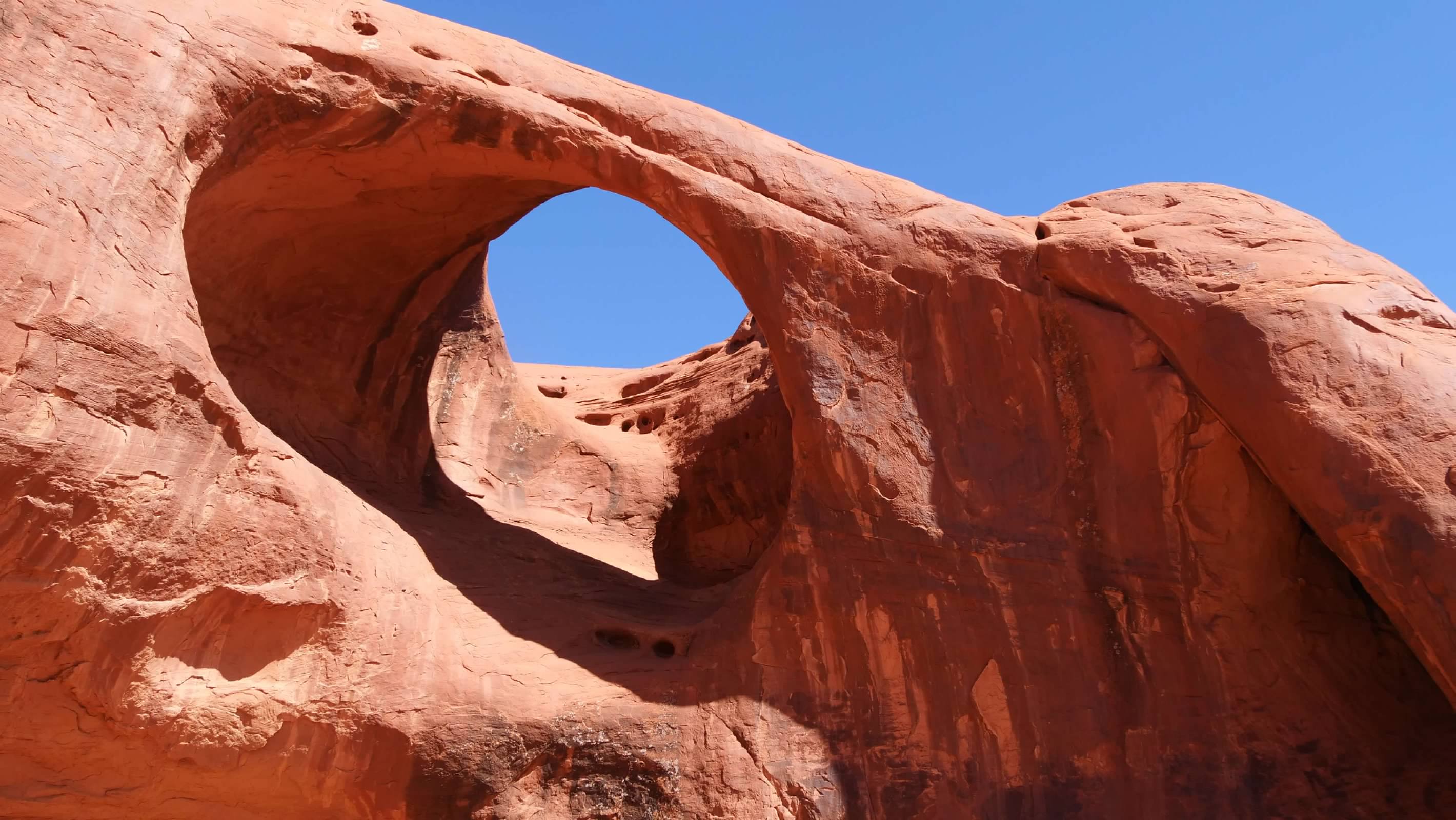
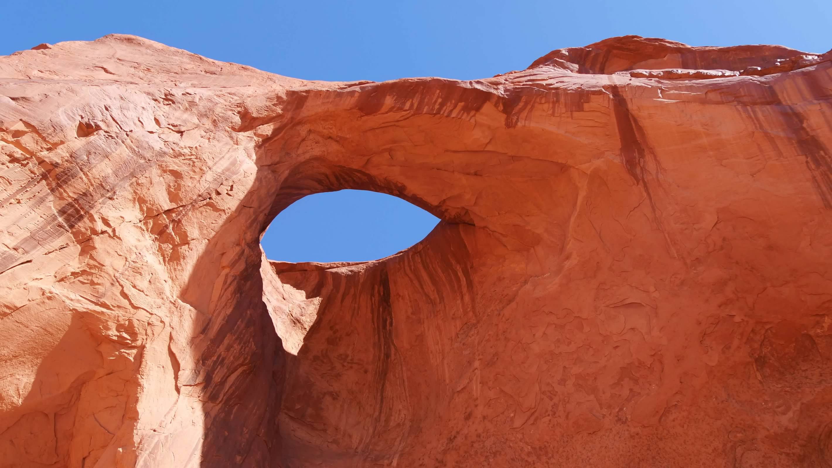
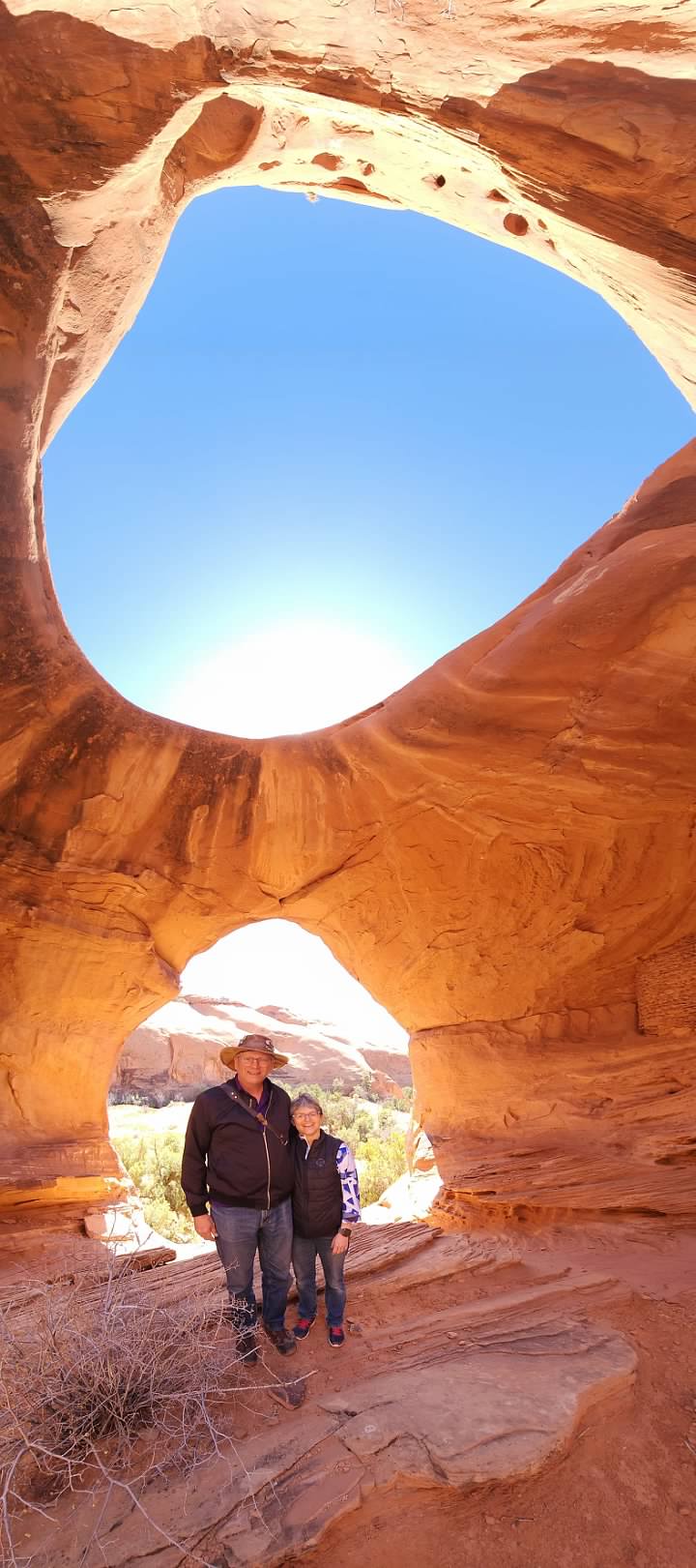
We then finished our tour of Monument Valley by visiting several of the arches located in the southern reaches of the Valley. While these might not be as impressive as some of the arches we've seen elsewhere, they were unique, and played a role in the Navajo stories our guide shared with us. Our guide also had suggestions for where to stand for photos, as well as tips for capturing interesting images of the arches.
PetroglyphsAncestral Puebloan ruinsAncestral Puebloan ruinsPictographs
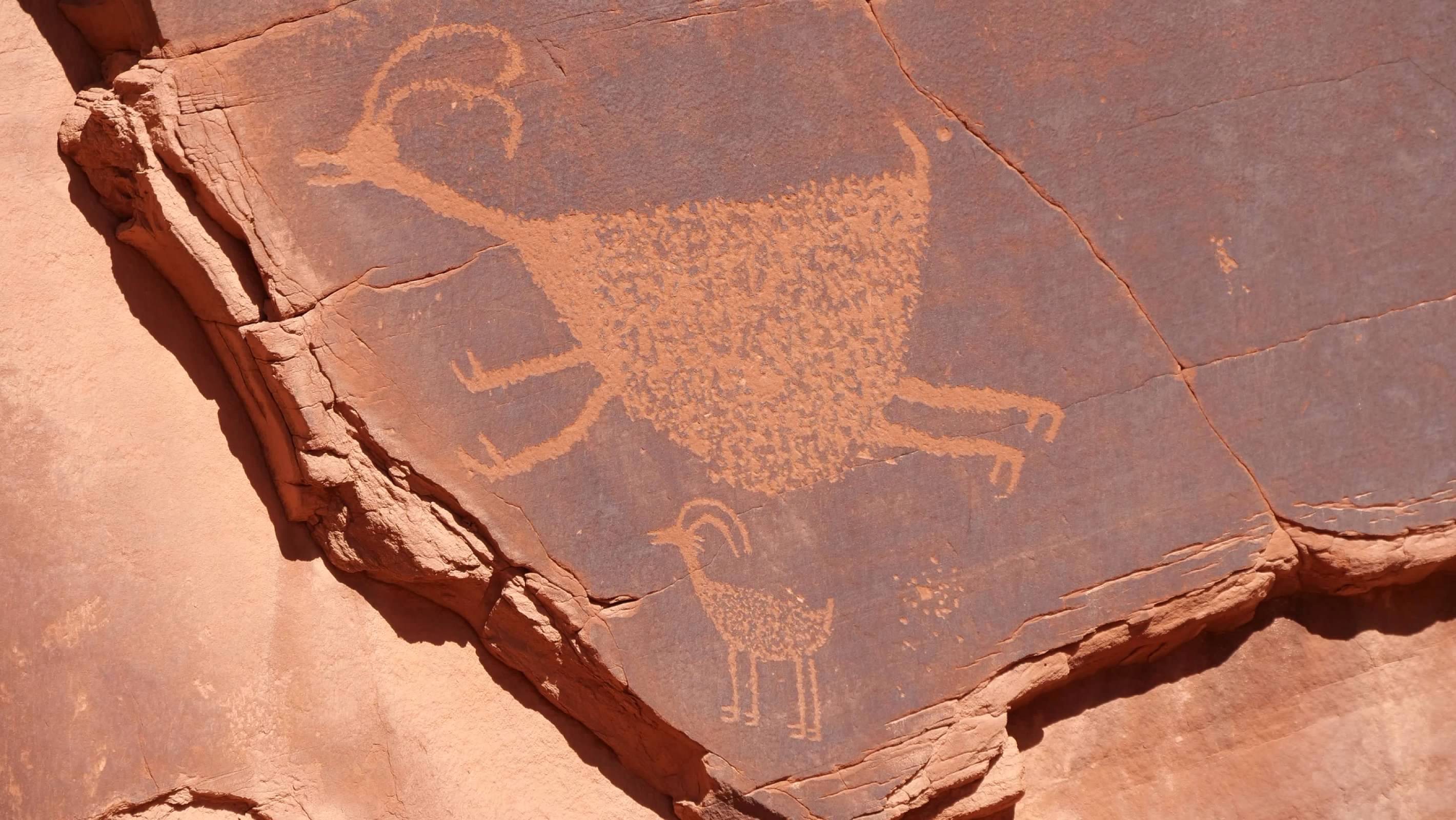
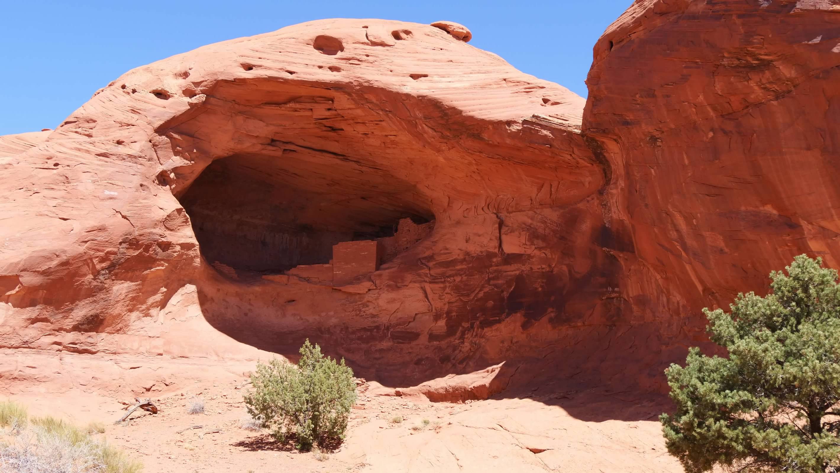
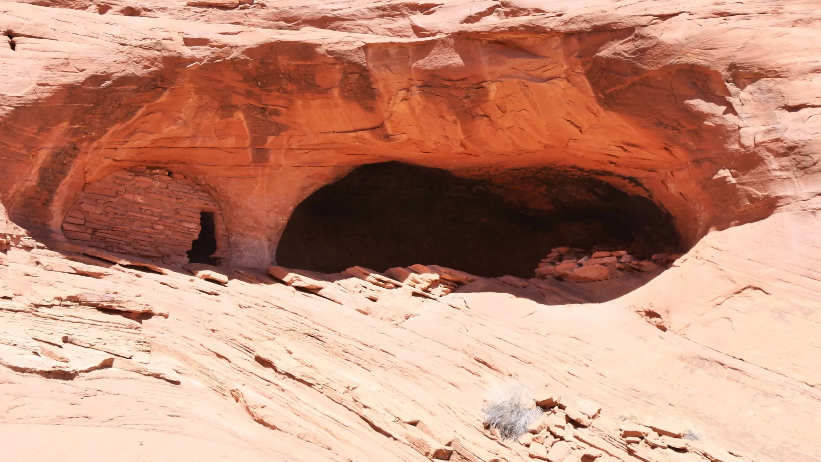
All too soon, our time in the Valley was over, and we found ourselves back at the start of the tour. Here we stopped for a brief lunch break, before we headed out for the second part of our tour. This tour was to the west of Monument Valley itself, on the other side of the ridge of formations that forms the western boundary of the valley. Here, we visited several sites with evidence of settlements by the Ancestral Puebloans, with ruins, as well as petroglyphs and pictographs on the rocks. There were also some additional arches to visit as well. The "road" here was very primitive, little more than tracks in the sand, and driving here required significant use of four-wheel drive and reminded us a little of some of the driving in the bush in Africa.
Honeymoon ArchHoneymoon ArchHoneymoon Arch
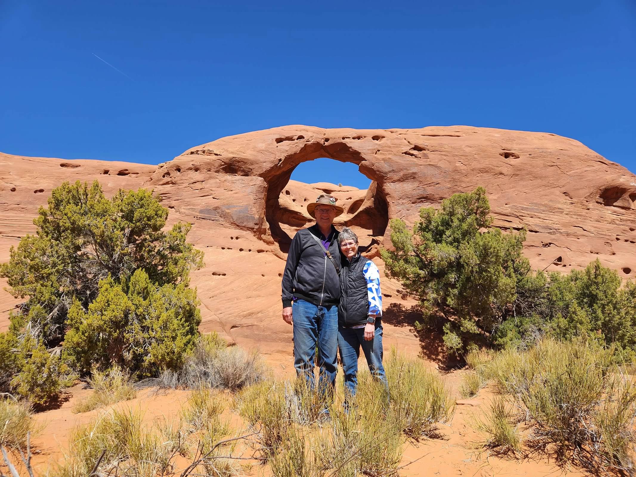
Eventually, our tour was completed and we were back at our car, ready to move on to our next stop. But even as we drove away, we weren't quite finished with Monument Valley. As we headed north on US 163 into Utah, we took a moment to stop at the site where the Forrest Gump scene was filmed. This has become a popular spot, where lots of people stop to take photos and shoot videos. As a result, the speed limit drops from 65mph to 45mph, in a effort to improve safety. The shoulders have also been widened and paved since the movie was made, again, improving safety along this stretch. Even though it wasn't exactly peak tourist season, we were still far from alone on this otherwise lonely stretch of road, and getting a shot without others in it was difficult enough that I didn't really try very hard. Still, it is an iconic vista, and was our last view of Monument Valley before we finally moved on.
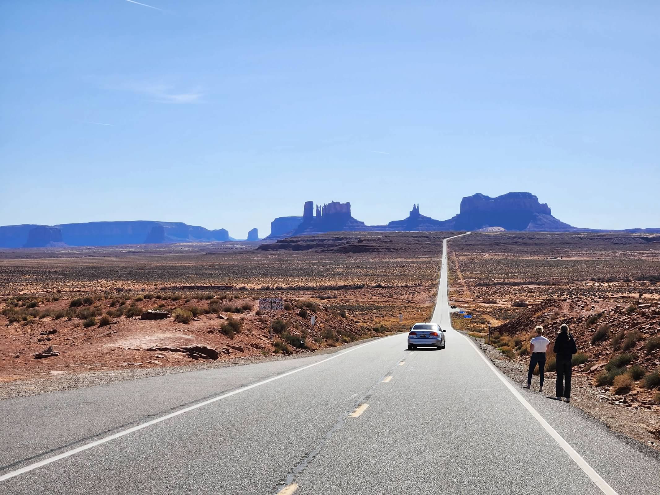
Forrest Gump point
expedition_retirement: (Hiking)
 After finishing our tours the Lower and Upper Antelope Canyons, we still had most of the afternoon free to do some additional exploring in the area. Anticipating this, I had researched possible hikes in the area, and found one in the Glen Canyon National Recreation Area across the Colorado River from Page that looked to be the right length and difficulty to suit our need. To get there, we had to drive by the Glen Canyon NRA visitor center at the Glen Canyon Dam, so we stopped to learn a little bit about the dam and Lake Powell, the reservoir behind it. We didn't spend a lot of time here, but it was interesting to see that the water levels in the lake have recovered a bit from the record low it reached in 2022. However, the lake is still well below its historically normal capacity, suggesting that continued conservation efforts are in order.
The bridge at Glen Canyon DamGlen Canyon DamGlen Canyon National Recreation Area
From the visitor's center, we continued out to the trail head parking area, just a couple of miles away. Our hike was about five miles, and was neither very long, nor particularly difficult. But the desert landscape was striking, and we got to explore some interesting sandstone formations. There were plenty of others out on the trail as well, many of them trying to capture the perfect selfie photos of themselves amongst the formations. The day was warm enough to be comfortable for walking, without being too hot, and we enjoyed the couple of hours we spent exploring this small area.
After our hike, we headed back into the city of Page so we could get something to eat before we needed to head out to Horseshoe Bend for sunset. We arrived about a half hour before sunset, and tried to figure out where to best photograph this incredible vista. I found myself struggling to capture the entire scene in a single frame with my camera. My widest angle focal length simply wasn't wide enough to get the whole thing. My frustration was increased when I saw all the other people around me successfully capturing the scene with their phones. As the sunset and I was still unable to figure out where and how to get the shot I wanted, my wife finally convinced me to pull out my phone and take my photo with that. Sure enough, my phone was able to capture a wider angle that successfully capture the entire scene, the way I envisioned it in my head. So much for all my expensive camera gear! I guess I'm going to need to remember that my phone should be considered part of my photography equipment.
Horseshoe Bend at sunset
expedition_retirement: (United States)
I first became aware of Antelope Canyon when Microsoft used a series of photographs from the canyon for one of the built in screensavers in Windows 7. Later, when we first visited Sedona, Arizona, we noticed that many of the tour companies there offered day trips up to visit Antelope Canyon. We were intrigued by the images, which were absolutely stunning, but decided it wasn't worth giving up an entire day in Sedona to see. Antelope Canyon could wait for another day. So, when we started thinking about our drive out and back for the bike tour, I naturally thought this was a great opportunity to finally visit the canyon.

Beyond the photos, I really knew very little about Antelope Canyon until I began researching for this trip. I knew that it was inside the Navajo Nation, but the significance of that wasn't immediately clear. One of the first things I learned was that there are actually two different canyons: an Upper and a Lower Antelope Canyon. After 11 people died in a flash flood in 1997, the Navajo Nation no longer allows free access to the canyons. All visitors are now required to be accompanied by a licensed tour guide. And each canyon is serviced by a different set of tour companies, so that which canyon you visit depends on which company you book with.

After looking at the various companies that offer tours in the Antelope Canyons, and comparing the reviews for each, I finally settled on Dixie's Lower Antelope Canyon Tours and Tsé Bíghanílíní Tours (for the Upper Canyon). Based on what I had learned, I decided to book the Lower Antelope Canyon earlier in the morning, and follow with the Upper Antelope Canyon tour later, around mid-day. This should give us optimum lighting conditions in each canyon during our tours. The tours were close enough together that we still had time to do other things that day, but spaced apart enough that we didn't have to worry about missing the second because of the first.

The other complication with booking these tours was ensuring that I was clear about exactly what time the tour began. This might seem like a trivial thing, but it is surprisingly challenging. The State of Arizona does NOT observe Daylight Savings Time, remaining on Mountain Standard Time year round. On the other hand, the Navajo Nation (which extends across state lines into parts of four states) DOES observe Daylight Savings Time, so that it is an hour earlier than the rest of Arizona from early March until early November. Further  complicating matters, the tour companies for the Antelope Canyon Tours all booked their tours using Standard Time, largely because of their close proximity to the city of Page, which is not in the Navajo Nation. So, while my phone might switch to MDT when I enter the Navajo Nation, my tour was booked in MST, and I needed to plan my arrival accordingly.

Ultimately, everything was properly booked, and we had no problems arriving in time for our scheduled tours. In fact, we were sufficiently early for our Lower Antelope Canyon tour that they added us to an earlier tour group. The Lower Canyon is surprisingly close to the road, and our tour was done entirely on foot. The tour started out walking down to the lower end of the canyon, and it was surprising how little evidence could be seen of the canyon, even though we were walking along side it, just a few dozen yards away from it. After descending a series of stairs to the entrance to the canyon, we began our return up the canyon. Lower Antelope Canyon is wider at the top and very narrow at the bottom, at times just wide enough to place a single foot on the sand at the bottom. We started at the deepest end of the canyon and walked uphill through the canyon. Along the way, our guide stopped regularly to talk about the geology of the canyon, to point out various formations, and to help take photos. It just happened that this was our wedding anniversary, and our guide captured a lovely photo of us at the point in the canyon called "bridal arch".
Anniversary photo
The views inside the canyon were every bit as spectacular as anticipated, and I ended up taking a LOT of photographs. I probably could have taken even more, but our tour had to keep moving because there was another tour group right behind us, and another behind that, etc. This has become an incredibly popular attraction, for obvious reasons, and the guides have to keep the groups moving so that everyone has a chance to see it. I can only imagine what it must be like during a peak tourist season when the tour groups are all filled to capacity. I have read complaints about how this congestion leads to an overall feeling of being rushed through the canyon. Luckily, it wasn't that crowded, and while we knew that other groups were following us, I never felt like we were being pushed through the canyon too quickly.
Lower Antelope CanyonLower Antelope CanyonLower Antelope CanyonLower Antelope CanyonLower Antelope CanyonLower Antelope Canyon
Eventually, we reached the upper end of the canyon and emerged back out on top of the sandstone shelf, not far from where we had started our tour. Because we had joined an earlier tour than what we had booked, we found ourselves with extra time on our hands, which allowed us to relax and enjoy a Navajo dance demonstration before we headed across the highway to check in for our second tour.

The name of the company we used for our tour of the Upper Antelope Canyon, Tsé Bíghanílíní, means "the place where water runs through rocks" in Navajo. This is the Navajo name for the Canyon, and a description that became easier to understand when we finally arrived at the Canyon. But first we had to wait. While we were early for our tour, we weren't early enough to have time to go elsewhere and do something else, so we simply waited at the check-in point until our tour was called to board the four wheel drive truck out to the Canyon. Unlike the Lower Antelope Canyon, the Upper Canyon is not conveniently located next to the highway. Instead, it is located about three miles up the wash, requiring an off-road vehicle to reach it. The tour time slots are coordinated so that the trucks from one company pass those from another as they travel to and from the Canyon, with those from a third sitting at the site when we arrived.

From our truck, we walked straight into the Canyon, which was visible as a crack in the sandstone cliff in front of us. As we approached, it was easy to see how water spilling out of that crack to lead to the Navajo name for this place. The Upper Antelope Canyon is wider at the bottom and narrower at the top, which made it easier to move around in, and created eye-catching beams of sunlight. These beams are the reason that the midday tours are more popular (and more expensive, too). Again, we were just one of a number of tour groups working through the canyon in succession, so we didn't have lots of time to dawdle. But we had enough time to take in the surreal shapes and colors of the sandstone. The tour guides had a similar routine, talking about the canyon, pointing out interesting formations, and helping us take photos.
A surreal shot of us in the Upper Antelope Canyon
Tsé BíghanílíníUpper Antelope CanyonUpper Antelope CanyonUpper Antelope CanyonUpper Antelope CanyonUpper Antelope Canyon
While our walk through the canyon was uphill, we didn't climb nearly as far through this canyon, and emerged from the canyon to find that the canyon sliced through a wall of sandstone. This meant that we had to climb up a ramp to a walkway across that sandstone slab and back down a set of stairs to return to the trucks for our return back to the highway. But before we did so, our guide stopped and gathered us around for a demonstration of how the canyons were formed. Using just the sand and a bottle of water, he showed how rainfall binds the sand into sandstone, how wind erosion removes the sand that isn't highly bound together, and how running water cuts through the sandstone to carve the canyons. It only took him five or ten minutes, but it was a vivid and easy to appreciate summary of the local geology.
Demonstrating slot canyon geology
Finally, we walked back to our trucks and rode back down the wash to the parking lot and our car. While there are certainly similarities in the appearances in both canyons, they are also both unique, and we are very glad we visited both.
expedition_retirement: (Bicycle)
 The morning following our final ride of the bike tour, we met early to catch our shuttles up to Sabino Canyon, where we would ride the sightseeing tram up and down the canyon, before our shuttle took us to the airport to end our tour. In order to avoid delays that might cause people to miss their flights home, the hotel prepared carry-out breakfast for us, which we ate in our room as we finished our packing and got ready for the day. We then carried our luggage out to be loaded, and boarded our shuttle.
Sabino Canyon
Sabino Canyon Recreation Area is part of the Coronado National Forest, and is accessed on a out-and-back roadway up into the canyon. While you can walk up the road (and it appears that many people do), you also can buy tickets for the tram tour, which allows you to hop on and off the tram at a number of stops along the road. The tram is a zero-emission electric vehicle, with open-air cars and a headset audio narration. The entire ride up the valley and back took about an hour. Because of our schedule, we didn't have time to hop off at any of the stops and explore, which is a shame because it appeared that there was plenty of exploring that could have been done. This is another place we need to come back and spend more time at.
Sabino CreekSaguaro at Sabino Canyon
But even just riding the tram up and back was stunning. The road follows the Sabino Creek along the bottom of the canyon, so that we found water and greenery here inside this desert. But beyond the valley floor, the steep sides of the canyon hosted a forest of saguaro cacti, remining us that this valley is an oasis in an otherwise harsh environment.
Saguaro at Sabino CanyonSaguaro at Sabino CanyonSaguaro at Sabino Canyon
After our tram tour was completed, we re-boarded our shuttles for the ride back to the airport, the end of our packaged tour. We said farewell to everyone from the group, made our way back to the car and spent the rest of the day driving north, through Phoenix, and on towards Page, Arizona (with a stop in Sedona, one of our favorite places in that part of the country, for dinner), where we would spend the next couple of nights.
expedition_retirement: (Bicycle)
Saguaro National Park
Our final day of riding took us from our hotel, back to the Tucson Loop and eventually out to the eastern portion of the Saguaro National Park. Here, we would ride around the 8 mile long Cactus Forest Drive, a one way, one lane road through the heart of the saguaro forest. The speed limit is 15mph, so we were moving right at the pace of the other traffic, which made for a very comfortable riding experience. And the scenery was out of this world. There were so many scenic vistas to enjoys, with a diversity of desert landscapes. But the star of the show was all the giant saguaro cacti. It was hard not to spend hours lingering along the way enjoying all the views, but our tour guides were waiting in the picnic area along the route with a picnic lunch for us.
Saguaro and prickly pearGiant saguaroEven bigger saguaroSaguarosSaguaro on the rocks
For years, our guides had been hearing from guests who had ridden in Europe about how good the food was there, and they took it a a challenge to provide an over-the-top picnic for us. And I have to say, I think they succeeded. They had a slow cooker of sausages (bratwurst and Italian), another slow cooker of chicken, potato salad, pasta salad, hummus, cured meats, cheeses, and so, so much more. We all ate our fill, and they ended up with significant leftovers.
Lunch!
After lunch, it was time to make our way back to the hotel for our final night there. The entire round trip from the hotel would have made for a VERY long day, so our afternoon ride only took us about 1/3 of the way back. We met our shuttles at a locally owned bike shop, with a Dairy Queen next door. While our guides loaded the bikes on the trailer, we enjoyed ice cream before we shuttled back to the hotel for our final dinner together.
expedition_retirement: (Bicycle)
 After our far too brief visit to the Arizona-Sonora Desert Museum, we mounted our bike for the longest ride of the trip. Our route was to take us up and over Gates Pass back to Tucson and then around the Tucson Loop bike trails system to our hotel. We left the museum parking lot and started out on Kinney Road, which is the main road into the western part of the Saguaro National Park, and thus had its fair share of traffic. The road was two lanes, without any shoulder, so the cars had to share the road with us and respect our right-of-way. Luckily, we were only on that road for about a mile before we turned off to the road over the pass. This road still had traffic on it, but it also had a significant number of bicycles, and presented a serious climb up to the top of the pass. Our e-bikes meant that the climb wasn't too burdensome, and the ride down the other side was all about managing our speed to ensure we didn't allow the bikes to go faster than was safe. The sides of the mountains as we climbed up, over, and through the pass were covered with thousands of tall saguaro cacti, a veritable forest of them.
Climbing up Gates PassSaguara cacti in Gates Pass
When we reached Tucson, on the other side of the pass, our route took us off of the roads and streets and put us on the excellent bike trails that make up the Tucson Loop. Our ride took us north along the banks of the Santa Cruz River until it met the Rillito River, where we turned and followed that most of the way back to our hotel. The last few miles put us back on city streets, but with bike lanes now. The Tucson Loop is not only a well maintained, paved bike trail, but it also links lots of park land tucked alongside the rivers. As we rode along, we saw roadrunners and whole colonies of Round-tail Ground Squirrels (which I mistook for tiny prairie dogs when I saw them...they look and behave similarly) all along the trail, especially along the Rillito River section. The river beds (completely dry this time of year) included numerous homeless encampments made up of tents and other make-do shelters. At one point, near the end of the ride, we saw some ahead of us, and arrived to find a brush fire down in the riverbed. Luckily a local was already calling the fire department, because I wasn't sure I would have been able to accurately describe the location to the dispatcher. We were still on the trail when the fire engine arrived and the fire fighters began rappelling down into the river channel to put out the fire.
Roadrunner with its dinnerRound-tailed Ground Squirrel
The total mileage for the day was more than 35 miles, but with the exception of the climb up Gates Pass, it really wasn't a difficult ride and it was a little hard to believe we had gone that far, except for the amount of time it took.
expedition_retirement: (Bicycle)
 Our second hotel, the Hacienda del Sol, was even more luxurious than our stay in Tubac. The complex started out as a school, but has long been a luxury hotel, once frequented by the Hollywood stars that made the Westerns in the desert outside the city. The rooms were huge and comfortable, with great views of the desert and the nearby Catalina Mountains.'

After a good night's sleep here, we were shuttled, with our bikes, over Gates Pass, west of the city, to the Arizona-Sonora Desert Museum. Located just outside the western unit of the Saguaro National Park, we had about an hour to spend here before we began our ride, which really didn't give us enough time to do the complex justice. We chose to focus on the desert trail, with its focus on the ecology of the desert and its flora and fauna. There were excellent examples of a number of different flowering cacti, and we actually got to see a coyote (sleeping in the sun) and a number of javelinas (sleeping under bushes, so they were hard to see and even harder to photograph). 
Flowering CactusFlowering cactusFlowering cactusFlowering cactus
Sleepy coyote
What we saw at the museum was impressive, but we barely scratched the surface. It is definitely something we will want to revisit and spend a LOT more time at if we ever get back to Tucson.

expedition_retirement: (Bicycle)
The third day of our tour began with us packing our luggage for the transfer to our second hotel on the north side of Tucson. We then boarded our shuttle vans for the ride up in the the desert to the little town of Arivaca. Located about 30 miles west of the interstate highway, this little town is isolated deep in the desert ranch country, about ten miles or so north of the Mexican border. We began our ride at a parking area for the Buenos Aires National Wildlife Refuge, just past the town. Because of the strong winds, our leaders shortened our ride a bit, cutting off a portion of the ride where we would be battling the winds, leaving most of our ride with both tail winds and a mostly down hill pitch.
Arivaca
When we reached the town, just minutes into the ride, we stopped for ice cream at a local general store that looked like it had been transported from another era. From there, our ride was all out in open range lands, with desert in all directions. The majority of the vehicle traffic we saw was from Customs and Border Patrol (CBP), and we past several CBP trucks parked out in the bush. On our drive out to Arivaca in the morning, we passed through a CBP checkpoint on the interstate, where we saw a car that was being very thoroughly searched (including the removal of interior body panels).
Riding through the desertDesert mountainsThe loneliest flag
With the downhill slope and the tail winds, this was an incredible fast and easy ride. The scenery wasn't awe inspiring, but it was pretty in its stark, desolate way. Near the end of the road, there was a pull-out with a memorial shrine. It wasn't clear if this was just a religious shrine or if it was build in someone's memory, but it clearly was visited on a regular basis, with various offerings left behind. Nearby, there was what appeared to be a rough grave site. I couldn't tell if it was an actual grave, or another memorial to someone. Either way, these were rather poignant out here by themselves in the middle of the desert.
Roadside shrineGrave or memorial??
As we neared the end of our ride, we had to slow down and pass through another CBP checkpoint. The checkpoint was closed when we arrived, and we were able to just proceed through, but it was slightly intimidating to have to ride through with all the barriers, signs, and warnings.
Longhorn Grill & Saloon
Our ride ended at the Longhorn Grill & Saloon, which faced us as we rode up to the final intersection of the trip. After lunch, we reboarded our buses and made our way back to Tucson and our second hotel.

expedition_retirement: (Bicycle)
The break between the morning and afternoon rides on the second day of the tour was at the Tumacácori National Historical Park. This site preserves the ruins of the colonial Spanish mission of San José de Tumacácori. Built in the 18th century by Spanish missionaries, it served a similar role as the missions in San Antonio...conversion of the indigenous people to Catholicism and teaching them how to become productive subjects of the Spanish empire. This site sits inside the territory acquired by the US in the Gadsden purchase of 1853, and was designated a National Monument by Theodore Roosevelt.
Tumacácori National Historical Park
The church interior is a ruin, severely damaged by treasure hunters who believed there was silver hidden here, although the exterior is remarkably well preserved. The mission complex still retains a portion  of its exterior wall, as well as ruins of other buildings on the property and a cemetery, located behind the church. This site also seems to retain some importance to the local tribes, and they apparently gather here from time to time. This was another fascinating look back into the Spanish colonial history of this park of the country.
Mission San José de TumacácoriCemetery at TumacácoriStorage pots at Tumacácori
expedition_retirement: (Bicycle)
The second day of our bike tour was an out-and-back ride, where we rode out to the end of the route and then retraced the same route back to our hotel. On the way out, we rode by the end-point of our morning ride, following the frontage road along the interstate highway for about half the ride before transitioning to a bike trail alongside a different road to the turn around point. I can't say that the scenery was particularly memorable ride, although the desert landscape is considerably different than what we've seen on earlier bike tours. The ride wasn't particularly difficult, so we made good time, which left us lots of time to explore at our stops.
Riding in the desertDesert mountains
On the way back to the end point of the morning ride, we made a stop at the 
Santa Cruz Chili and Spice Company, just a short distance from the end of the ride. The scent of the spices greeted us even before we walked into the shop, and it was fun exploring the various spices and seasoning mixes they offered. We ended up buying some seasoning and a couple of soup mixes to bring home to enjoy. We then finished the last, short portion of our ride to the Tumacácori National Historical Park, another colonial Spanish mission site. We spent quite a bit of time exploring this site before we mounted our bikes for our shorter afternoon ride back to the resort.

The afternoon ride took us back through the town of Tubac, and this time we stopped to explore the town. We had a light lunch in the deli here before walking around to take a look at the various art galleries and shops that make up the town. Many of these shops included extensive collections of various sculpture work in various styles, much of it influenced by the local Hispanic culture. After we explored the town, we continued our return ride, making a short stop at the cemetery at the edge of town along the way.
Sculptures in TubacTubac cemeteryTubac cemeteryTubac cemetery
 
expedition_retirement: (Bicycle)
The tour operator for our bike tour assumed that most people booking the tour would fly to Tucson, so transportation was arranged to/from the Tucson airport at the beginning and end of the tour. When I looked into parking near the airport, I discovered that the economy parking at the airport was only $5/day, so our plan was to just leave the car in long term airport parking and meet the group in the terminal for the tour. We arrived early, found the meeting place and settled in to await the arrival of the rest of the group, and our transportation.

The majority of the guests on this tour were from our ski club, so there were plenty of familiar faces as we gathered in the baggage claim area. But there were others as well, and we tried to make a point of introducing ourselves to everyone. Soon enough, we had loaded our luggage into a trailer and boarded the two vans that would transport us to our first hotel and the beginning of our tour.
Prickly pears along our bike route
The first two nights of the tour we stayed at the lovely Tubac Golf Resort and Spa in Tubac, Arizona, about 40 miles south of the airport. After getting settled into our very comfortable accommodations and changing into our riding clothes, we gathered for our introductory ride. As with all of our other bike tours with this company, this first ride was a warm-up, a chance to make sure our bicycle was properly adjusted and correct any issues that might exist. As such, this was a short ride, only about 9 miles, and it wasn't particularly scenic, just a loop out of the resort and across the interstate highway, with the longest stretch being on the frontage road parallel to the interstate to the next road that crossed the highway and then back to the resort, with a loop through the quaint artist colony town of Tubac.
Wedding chapel at the Tubac Golf Resort & Spa
That evening, we had time to wander the grounds of the resort before our group dinner. In addition to the golf course, the resort also had a wedding chapel designed to look like an old Spanish mission, and a lovely pool area. Scattered around the grounds were old wagons and carts and other artifacts that seemed intended to invoke the history of the area.
Old pickup truck at the resortOld mining cartOld farm cart
After dinner, we settled in for the night, ready for a longer ride the next morning.
expedition_retirement: (United States)
We arrived in Tucson the night before our bike tour began. As we settled into our accommodations for the night, we realized that our check-out time was more than four hours earlier than the scheduled time when we were to meet for the tour. That left us with an entire morning with nothing to do but wait around. Since neither of us liked the idea of just sitting and waiting for the tour meetup, I decided to see if there was anything else in the area that we could do that would fit into our available time. One possibility that immediately jumped out at me was the Mission San Xavier del Bac, located on the Tohono O'odham reservation just outside Tuscon. It looked gorgeous and interesting, but no tours would be available because it was Sunday, and the mission would be in use for Sunday masses.

Looking down into the silo at the missileAfter some more searching, I discovered the Titan Missile Museum. This museum preserves the only remaining Titan II missile silo complex from the Cold War, complete with a missile inside it. The opportunity to visit an actual ICBM silo and get a tour inside the command center and silo was completely unexpected and unique, so we quickly decided that would be our morning activity. We ended up arriving a little early for our tour, so we had time to explore the grounds of the silo compound, including taking a look down into the silo from the ground level. On our actual tour, we walked down the stairs into the silo, to the command center, where we learned how the silo was staffed (2 Air Force officers and 2 enlisted Airmen at all times) and what their duties entailed (primarily maintaining the missile readiness and launching the missile if that order was issued). We also walked through a simulation of the launch sequence that would have been used to launch the missile. The underground complex was designed and built to withstand a close strike by a nuclear weapon and still be functional to launch a retaliatory missile. The command complex included a 30 day supply of food and water, and in the event of a nuclear strike, the crew was to remain in the silo for 30 days after launch before venturing out to the surface.
The missile command center

The Titan II missile, in its siloWe then walked through the tunnel that connected the command center to the missile launch tube, where we got close up look at an actual Titan II missile (disabled and without a warhead, obviously). Standing there examining the missile and its surroundings reminded me that I had listened to an episode of "This American Life" about an incident involving a Titan II missile that exploded in its silo in 1980 near Little Rock Arkansas. It was sobering to stand that close to a missile with that much power, even if it didn't have any fuel or a warhead. The madness of the Cold War and the doctrine of Mutually Assured Destruction haven't felt that real to me in many years.

The Titan II missiles were the first ICBMs that used a stable fuel and could be stored, fully-fueled and launch ready, indefinitely. They were armed with a 9 megaton yield thermonuclear warhead, and were located in silos at three locations: Tucson, Little Rock, and Wichita. The Titan II remained in service far beyond its original intended service life span and were finally decommissioned in the 1980s. In compliance with the START treaties in the 1990s, the other silos were destroyed, and the silo cover for this one is locked in a half-open configuration visible by satellite to ensure that it cannot be used to launch a missile. In addition, a hole has been cut in the re-entry vehicle portion of the missile to show that it does not contain a warhead.

This visit was not excessively long, but was highly informative and shed light on what life was like for the members of the Air Force who were tasked with operating our nuclear arsenal. While this stop might not have been on our original itinerary, it was well worth the extra effort to visit.

Profile

expedition_retirement: (Default)
Expedition: Retirement

April 2025

S M T W T F S
  12345
6789101112
13 14 15 16 17 1819
20 21 22 2324 25 26
27 28 2930   

Syndicate

RSS Atom

Most Popular Tags

Expand Cut Tags

No cut tags